Wake Up Washtenaw "White Paper"
6.2 Compact Transportation-Oriented Infill Project
 One of the most exciting potential
infill projects in Washtenaw County is the location at which the former
Michigan Central Railroad[i]
and the Ann Arbor Railroad cross. In a post-automotive age, this would be the single
most important crossroads of the region west of Detroit and east of Jackson:
the place where the east-west rail line from Detroit to Chicago meets the
north-south line from Toledo to Traverse City.
One of the most exciting potential
infill projects in Washtenaw County is the location at which the former
Michigan Central Railroad[i]
and the Ann Arbor Railroad cross. In a post-automotive age, this would be the single
most important crossroads of the region west of Detroit and east of Jackson:
the place where the east-west rail line from Detroit to Chicago meets the
north-south line from Toledo to Traverse City.
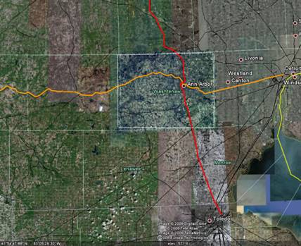
This cross-over is also key to sustainable, transit-oriented development in Washtenaw County, because of the potential of each of the two rail lines as corridors for sustainable development. For transit to be a practical and meaningful alternative to driving, it is essential to be able to transfer quickly and conveniently from one transit line to another. In countries where passenger rail is healthy, such as Europe and Japan, stations are placed at the junctions between lines to facilitate transfers. Just as importantly, healthy passenger rail systems give rise to lucrative retail, office, and lodging venues in and around such rail transfer points.
Considering both the importance of having a transfer point at this junction, and the business potential of transit oriented development, the crossing of the Michigan Central and Ann Arbor railways is probably the single most valuable location for TOD in Washtenaw County. It also has potential as a “green” development, because of adjacent empty land that could be used as either park or urban farmland.
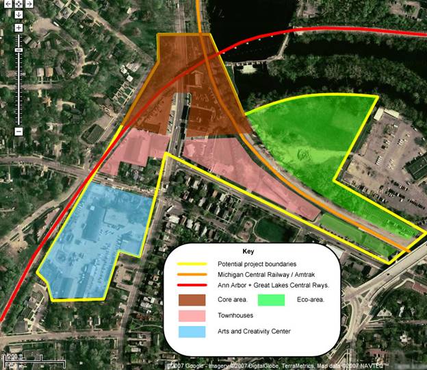
Let’s take a look at the details. An aerial photo (next page) is overlaid with proposed areas of development.
The north-south Ann Arbor Railroad[ii] (AA, red line) enters the area from the southwest after having passed immediately west of downtown Ann Arbor, following the Allen Creek valley. Along most of its route it is elevated on an embankment (except for the Summit Street crossing, which is at grade). The line swings eastward in a broad curve, passing over Main Street and the Michigan Central line. From there, it crosses the Huron River just upstream from Barton Dam on a single-track viaduct, arriving at the north shore of the river going in an easterly direction. Just beyond the east edge of the map, the line swings northward, paralleling Plymouth Road for a while as it aims for Whitmore Lake, Howell, and points north. On the north bank of the river, the track belongs to the State of Michigan[iii], and is leased to Great Lakes Central Railroad[iv], a Federated Capital Corporation subsidiary[v]. From the bridge south to Toledo, the line still belongs to the original Ann Arbor Railroad. Shortly before crossing Main Street, there is an embankment which formerly carried a steep track down to the Michigan Central line (MC, orange line) for exchange purposes. That track has long since been torn up, and the combination of the track angles and grade separations makes it impractical for trains to change from the MC to the AA line.
 The former Michigan Central line enters
the map area near the southeast corner and curves north as it follows the
Huron River valley. The original Michigan Central Ann Arbor station, currently
a restaurant, is just off the map on the right. The Amtrak station is a
small building south of the track, under the shadow of the Broadway Street
bridge. Despite its humble size, this station is the busiest in Michigan,
and second only to Chicago Union Station in passenger activity along Amtrak’s
Wolverine Corridor: 144,542 passengers in 2008[vi].
The former Michigan Central line enters
the map area near the southeast corner and curves north as it follows the
Huron River valley. The original Michigan Central Ann Arbor station, currently
a restaurant, is just off the map on the right. The Amtrak station is a
small building south of the track, under the shadow of the Broadway Street
bridge. Despite its humble size, this station is the busiest in Michigan,
and second only to Chicago Union Station in passenger activity along Amtrak’s
Wolverine Corridor: 144,542 passengers in 2008[vi].
The current composition of this section is a mix of mostly single-story sales and office buildings, automotive repair facilities, and two-story frame residences. The City of Ann Arbor had its utility vehicle yard south of Summit, between Main and the AA line, though this has recently been sold.
The shape of the area is challenging because existing residences have a distinct midwestern charm, and it would be insensitive to destroy them. The remaining space currently consists of four disparate areas:
- North (brown): the core rail crossing area, with small offices and automotive shops;
- Southwest (blue): the former city maintenance yard;
- South central (pink): small commercial buildings with parking facilities;
- East (green): potential open space – south of the MC line, owned by Amtrak and occupied by the current small, one-story station building and adjacent parking lots; north of the line, owned by Detroit Energy, and possibly contaminated.
There are several ways this area could be developed, but the general idea is to focus intensive commercial and hospitality facilities as close as possible to the actual crossing of the tracks. The reason for this is simple: to make it as easy as possible for transfering passengers to walk from one train to another. As they walk and wait for their train, they should be surrounded by inviting and relaxing opportunities to browse for books, gifts, a cup of latte, a snack, or a meal. For those with a longer layover, comfortable hotel accomodations should be within easy walking distance. Office and living space should be almost as close, and all should be designed to be as energy-efficient and self-sufficient as possible. With relatively little open space, and located within the City of Ann Arbor, there would be no need for the development to provide its own water or dispose of its own waste; however, the available open space could be used for urban farming as well as recreation.
The plan suggested here is anchored by a high-rise building in the core area, straddling both rail lines and Main Street. Building over the rails and street provides a covered (but well ventilated) space for passengers transfering between trains and from automobiles or buses to trains. It also makes more efficient use of the limited space. Since the rail lines are on separate levels, passengers would transfer between them using escalators and elevators. A bus terminal for local and regional service, also under cover, would be located nearby, probably on the same level as Main Street and the MC rail line. Above the transportation levels would be retail space, and above that, office, hotel and possibly residential space as well.
In the south central areas along Depot Street and Main Street, compact residential development consisting of apartments or townhouses could be built. An existing three-story office structure recently completed at 201 Depot Street would fit nicely into this area.
 The
property highlighted in blue, formerly the city utility yard, could also
be developed as compact residential or mixed-use space. A related alternative
is to use the space as an arts and creativity center. (This idea was proposed
at a Calthorpe town meeting sponsored by the Downtown Development Authority.)
The purpose of such a center is to encourage artistic creativity as an essential
part of Michigan’s economic development. Evidence shows that where creative
arts flourish, engineering and technological creativity thrives in conjunction.
A creativity center would include affordable living space, studio facilities,
galleries, and performance spaces, as well eating and entertainment venues.
The
property highlighted in blue, formerly the city utility yard, could also
be developed as compact residential or mixed-use space. A related alternative
is to use the space as an arts and creativity center. (This idea was proposed
at a Calthorpe town meeting sponsored by the Downtown Development Authority.)
The purpose of such a center is to encourage artistic creativity as an essential
part of Michigan’s economic development. Evidence shows that where creative
arts flourish, engineering and technological creativity thrives in conjunction.
A creativity center would include affordable living space, studio facilities,
galleries, and performance spaces, as well eating and entertainment venues.
The green areas on the map are actually “brown”: either parking lots, small buildings, or potentially contaminated land. Their location near the river makes them ideal, once remediated, for recreation and urban farming.
An interesting opportunity exists because of the proposed Ann Arbor Greenway, which runs roughly along the AA line in the Allen Creek flood plain. Much of the land proposed for this development is in the proposed Greenway area, so they might be perceived as mutually exclusive. However, the two plans can not only coexist, but thrive together. New development of this type can create green space to be enjoyed by residents and passers-by alike. Since the land is a flood plain, buildings should be elevated above 200-year flood levels, leaving space below to weave paths and shade-loving shrubbery around a resurrected Allen Creek, which is now largely buried in an underground culvert. This is an excellent place to exercise creative landscape architecture, with a result which could greatly enhance the area. The core building itself would be situated over the mouth of Allen Creek, where it flows into the Huron River. The challenge of creating a space at the base of the building that not only accomodates the creek, but celebrates it, would result in architecture worthy of distinction. (The illustration here shows Western Michigan University's College of Engineering and Applied Science.)